Posts Tagged ‘Hurricane’
Where is Hurricane Ike going?
Update: A Texas landfall as a major hurricane now looks likely.
Noticing a theme on the blog lately? The storms are just lined up this summer. As of September 4, Ike is a very strong category 4 hurricane with winds of 145mph. Here is the current tracking map, with intensity, from Weather Underground:
This is not good
There is still a lot of margin of error on the long term track of this storm. The southern most track potentially gives us a Gulf of Mexico storm, and the northern most track offers the possibility of Ike recurving out to sea. Pretty much any path looks grim for the Bahamas though, and if you are on Florida’s east coast then you need to be paying close attention. Here are the latest model runs:
One of these might be accurate
As always, the best place to go for information on any storm is the National Hurricane Center.
Where is Hanna going?
As of September 2nd, Hanna looks to grazing the east coast of Florida by the end of the week, and then moving northward towards Georgia or the Carolinas. The National Hurricane Center has more info.

Official NHC track
One of the best ways to measure Hanna’s potential impact is by looking at the probabilities of tropical storm force winds hitting within the next five days:

Windy
McCain and Katrina
So three years ago, right when Katrina was making landfall, what was he doing? This:

Party on
Later that same year, as Hurricane Rita was making landfall, McCain was asked about Michael Brown (former FEMA director whose previous experience was running running the Internation Arabian Horse Association):
More at Daily Kos
Where is Gustav going?
Update (August 30): This post is getting a lot of hits via Google, so I wanted to drop in a more updated map. Gustav has grown into a large storm, and will impact areas beyond what is indicated by the National Hurricane Center track line. Speaking of which, go to the NHC for the latest updates. The graphic below is the probabilities of a location undergoing tropical storm force winds or greater in the next 5 days. Gustav’s impacts are clear, and on the right side you can see the emergence of Hanna. This is one of the best graphics to use to determine the impact that the storm will have on you (aside from storm surge).

Click to embiggen
In short, maybe New Orleans or maybe south Texas. The National Hurricane Center lays it out like this:

Click to embiggen
There is a high pressure system that will possibly interact with Gustav. Some models predict little interaction and steer it towards New Orleans. Still others predict a strong interaction and push Gustav into the western Gulf. Here are the latest model runs:

Click to embiggen
There is a lot of uncertainty with this storm. What everyone does agree on is that it should intensify into a major hurricane once it hits the open waters of the Gulf.
Oh, and as for Tropical Storm Hanna, the models are currently just a jumbled mess:

Click to embiggen
Which way is Fay going?
Update: As of Monday afternoon, the NHC has Fay making landfall in southwest Florida.
As of Sunday evening, Tropical Storm (and soon to be hurricane) Fay is just south of Cuba. The National Hurricane Center forecast currently has Fay making landfall as a hurricane in the Big Bend region of Florida.

Click to embiggen
The path it follows could make a huge difference. If it hugs the right edge of the cone, then Fay gets very little time over water to recover from its time over Cuba and would be more of a rain event for south Florida. If it tracks along the western edge of the cone, then it would spend a lot of time over the very warm waters of the Gulf of Mexico. That could make for a nasty storm. Also bear in mind that the strongest winds are usually found in the northeastern quadrant of a hurricane, so traveling parallel to the Florida coast could deliver quite a beating.
The NHC generates their forecast path based on the output of several computer models. Here are the latest model runs for Fay:

Click to embiggen
The best thing to do, as always, is to keep watching and make sure you are prepared.
How good are hurricane forecasters?
I just came across this article about the Colorado State University hurricane team predicting 15 tropical storms with 8 of those becoming hurricanes for the 2008 season. It mentioned that some of their predictions had been a little off, but I was curious for a little more information. So I headed over to the forecast page for the team and found that they helpfully provided a very detailed analysis.
To check their results for accuracy, I am going to use their predictions from around June 1st of each year since that is the first day of hurricane season. Anyway, here are the results:
Named Storms:
- 2000: 12 predicted, 14 actual
- 2001: 12 predicted, 14 actual
- 2002: 11 predicted, 12 actual
- 2003: 14 predicted, 14 actual
- 2004: 14 predicted, 14 actual
- 2005: 15 predicted, 23 actual
- 2006: 17 predicted, 9 actual
- 2007: 17 predicted, 14 actual
Hurricanes:
- 2000: 8 predicted, 8 actual
- 2001: 7 predicted, 8 actual
- 2002: 6 predicted, 4 actual
- 2003: 8 predicted, 7 actual
- 2004: 8 predicted, 8 actual
- 2005: 8 predicted, 13 actual
- 2006: 9 predicted, 5 actual
- 2007: 9 predicted, 6 actual
So how did they do? Ok, I guess. From 2000 to 2004, they absolutely nailed it but then they completely fell apart. 2005 and 2006 are off by margins of 50% and 2007 is pretty shaky. I’m torn on if it is worthwhile to give publicity to these predictions. They can clearly be wildly off, but they do raise hurricane awareness right before the season starts.
I can conclusively say, however, that the members of the hurricane team desperately need makeovers. Believe it or not, the picture below is from the year 2000. Guys, get out of the lab every now and then.

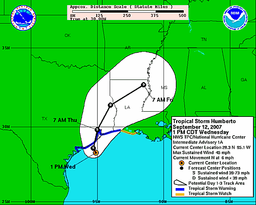
Tropical Storm Humberto forms in the Gulf of Mexico
Tropical Storm Humberto has formed just off the Texas coast and should make landfall this evening with winds roughly around 50 – 60 mph at landfall. Humberto is a slow moving storm, and the primary danger will mostly likely be in the form of flooding. The National Hurricane Center has more.
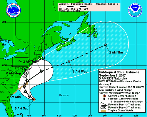
Subtropical storm Gabrielle forms in the Atlantic
Subtropical storm Gabrielle formed just off the east coast of the United States last night. As of this morning, it has winds of 45 mph and is expected to make a brief landfall around the Outer Banks of North Carolina on Sunday. Gabrielle will make landfall as it recurving towards the northeast, so its time over land should be brief before it heads back out to sea.
What is a subtropical storm? The Central Florida Hurricane Center defines it as a tropical storm with a warm core at lower levels and a cold core at higher levels. A regular tropical storm has a warm core, and an extratropical storm has a cold core, so this is sort of a hybrid system. Of course, especially if you live in the Carolinas, it should be treated no differently than any other tropical system.
The National Hurricane Center will have updates on the path.
Hurricane Felix Radar
Wow, this blew up to a category 4 in a hurry, and is expected to become a category 5 in a day or two. Scary looking storm.
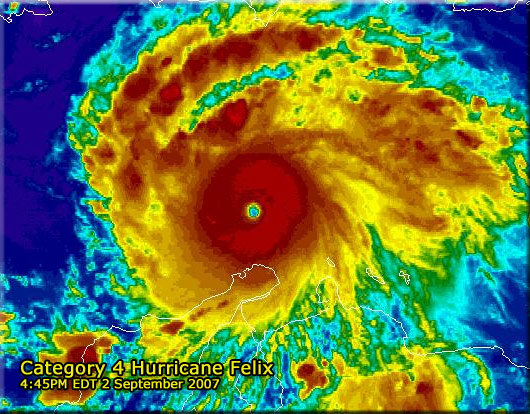
[image from FLHurricane.com]
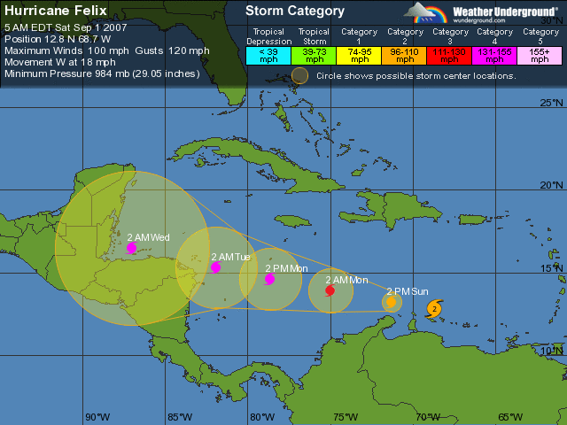
Hurricane Felix in the Caribbean
Hurricane Felix is churning through the Caribbean, on a similar, though more southern, track as Hurricane Dean. The computer models are in good agreement that it will hit the Yucatan, most likely impacting Belize directly. Felix is forecast to be a category 4 storm at landfall, with winds between 131 and 155 miles per hour.
